| Schwierigkeit |
mittel
|
|
Aufstieg
|
86 hm |
|
Abstieg
|
1102 hm |
| Tiefster Punkt | 932 m |
| Höchster Punkt | 1964 m |
|
Dauer
|
2:47 h |
|
Strecke
|
9,0 km |
HPB Viehhofen: Zell am See & The Schmittenhohe

Quelle/Autor: Holiday Property Bond Walks

Foto: Holiday Property Bond Walks, Holiday Property Bond Walks
Die Tour
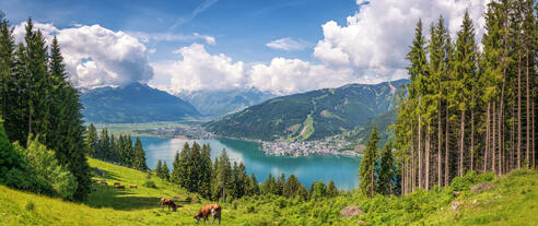
A fine example of the use of a cabin lift to reach the top of Zell’s own mountain at 1,965m (6,449 ft) without effort. The cabins are large gondolas, operating on a time-tabled basis. This route then follows the broad high ridge for some distance before commencing the long descent back to Zell.
A fine example of the use of a cabin lift to reach the top of Zell’s own mountain at 1,965m (6,449 ft) without effort. The cabins are large gondolas, operating on a time-tabled basis. This route then follows the broad high ridge for some distance before commencing the long descent back to Zell. The walking is quite easy and entirely safe, although some walkers might not enjoy prolonged descent. Two further peaks - the Salersbachkopf and the Sonnkogel - are short diversions from the basic route; a small extension can be made to include the Wankrautkopf.
Tracks and roadways are all good.
The Elizabeth Chapel at the Schmittenhohe summit adds historic interest.
Start/car parking - Any of the parking areas serving the base station of the Schmittenheohe Seilbahn cabin lift, situated about 2 km (1¼ miles) above the centre of Zell am See. From Viehhofen turn right at the traffic lights in Zell (signposted Schmittenheohe Parking - Post Office is on your left just after the turn), and drive directly to the cable car base station. At the lift station, try to pick up ‘Walking Paths, Zell am Zee & Kaprun’ for a decent map.
WALK
At the top station, there is a cafe, a hotel/restaurant and a new building. Walk around and admire the views in all directions then, with the bildings on your right and the tiny chapel behind you, walk forward along the track to the signposts. Either continue down the track (path 67) to ‘Sonnkogel uebers Salersbachkopfl’ and Hochzelleralm Restaurant’ or fork right for a few yards to the picnic area with information panels. From the picnic area you can also descend directly on path 68, which joins path 67 at the bottom of the slope.
The combined track passes below the Hochzelleralm Restaurant, becoming the Hoehenpromenad downhill to a first col. The views from along the ridge are extensive, including Zell and its lake. Rising past a cabin and some ski lifts, the Glemm Valley is now in view to the left and there are large sculptures by the wayside. Following a ‘Sonnkogel 30 minutes’ signpost, keep left to rise towards the Salersbachkopf peak - 1,734m (5,691 ft) - the actual Salersbachkopf peak is a short diversion to the left of the track.
Pass the top station of a ski lift. The signs include ‘Viehhofen 2 hours’. Continue along a broad track, downhill, towards ‘Sonnkogel’. Pass a second col before rising to reach the next peak, Sonnkogel - 1,856m (6,091 ft) - again the peak is a short diversion to the left of the track. Here is the top station of the Sonnkogel lift (for a short-cut down to the valley) and a small children’s play area.
From Sonnkogel continue down a broad roadway, path 64, by the edge of coniferous woodland and bilberry; pary way down, Viehhofen village is in view to the left. Reach a third col with a ‘Zell am See’ sign. From the fol, rise for 50m to a fork. (For the peak of Wankrautkopf go left at the fork or an out and back extension to the route).
Otherwise, start the descent by forking right, passing below the Schmiedhofalm restarant, along an unsurfaced roadway which twists and turns, pasing through forest and under a ski lift to reach a junction with signs. Turn sharp right for ‘Zell am See’. Go under more ski lifts; pass the Berg Hotel and the top station of the Sonnalmbahn ski lift.
From here, the walk is mostly through the woods with no views. An option, to save one’s knees on the descent, would be to take the Sonnalmbhan lift back down, shortening the walk by about 45 minutes. Otherwise, continue along the Sonnalm Weg, still descending steadily. Pass a mountain stream on a bend; there is a sudden view of the lake. Continue downhill, following signs for Zell am See (the estimated times vary). When you start to see signs for the parking at the cable car base station, follow these instead of the Zell signs (which will lead to the lake). The parking areas soon come into view.
Info
Karte
Details
|
Kondition
|
|
| Technik |


